
Last 2012, I left Manila to work in Pampanga. Every time I went home and came back, I always see this lone land standing from the flat plains of Pampanga known as Mt. Arayat. It is noticeable because it is the only elevated land around the area. Many times, I got curious of what lies there. One time, I was able to see it at a nearer position. I got invited by one of my friends to visit their farmland just a few kilometers from the mountain and swim in their swimming pool. A swimming pool in the middle of their cornfield with Mt. Arayat as the view! Just seeing it made me astonished by this mountain.
BACK IN PAMPANGA
Last March, one of my friends told me to organize a climb to Mt. Arayat. After months of not climbing, I said yes and organized it. The night before the trip, I was thinking of canceling it because I was not feeling well for almost 2 weeks but nonetheless, we still continued. Excited about being in the mountains again, I packed my stuff and pushed through. Finally, after 5 years, I’m back in Pampanga to conquer a mountain.
The journey to the jump-off took us a while. We took the long way going to the jump-off, instead of the short one, because of the availability of the buses going across SM North EDSA. From there, I based the routes on my past travels in Pampanga.
MT. ARAYAT
The path to the jump-off is a known place for pilgrims during the Holy Week season. There are statues that serve as the markers for the “Stations of the Cross”. Near the 7th Station is where the DENR Registration Area is located. We registered, paid the environmental fee of P30, and secured our guide. Mt. Arayat has two peaks called the North and the South Peaks. We only took the Backtrail package which only aims for the North Peak. Our guide suggested that we should also include White Rock and Haring Bato. These were additional view decks and conquer points around the mountain.
")
")
") After securing our guide, we continued our climb still following the trail of the Station of the Cross. I started to think if I can reach the summit. Bit by bit, I felt my body becoming heavy and the trail started to become steep. I was exhausted and breathing heavily. No exercise and feeling sick, I was starting to get worried. I took every step slowly and took a lot of rest. Fortunately, the trail was covered by trees. We were protected from the heat of the sun. I was thankful for the mountain being still rich in trees.
After securing our guide, we continued our climb still following the trail of the Station of the Cross. I started to think if I can reach the summit. Bit by bit, I felt my body becoming heavy and the trail started to become steep. I was exhausted and breathing heavily. No exercise and feeling sick, I was starting to get worried. I took every step slowly and took a lot of rest. Fortunately, the trail was covered by trees. We were protected from the heat of the sun. I was thankful for the mountain being still rich in trees.
")
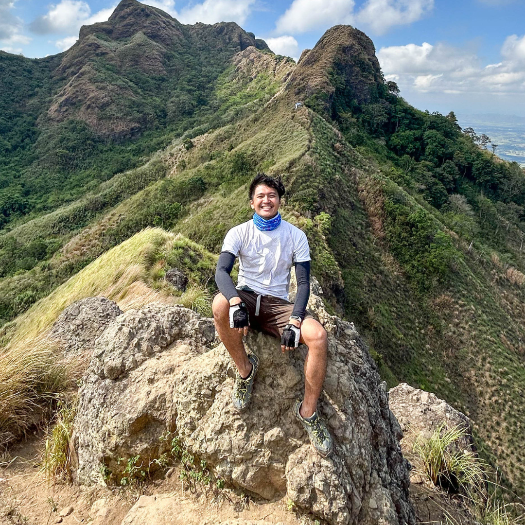
WHITE ROCK, NORTH PEAK, AND HARING BATO
Our first conquer point was the White Rock just at the midpoint of the mountain. It has a view of the Western towns of Pampanga and from there, everyone can see the North Peak. Upon looking at it and expecting the distance and elevation from where I stand, I took a deep breath and pushed myself to reach it. There’s no turning back.
")
")
The North Peak is the actual summit of Mt. Arayat. There lies a communication station for the Army or the Police. The summit offers a wonderful view of the plains and Pampanga River surrounding the area that took our breath away, including the South Peak and Pinnacle Peak just in front of us. We took some photos and rested for a while in their small hut. I was very tired and slept it out for a few minutes before descending to Haring Bato.
")
")
")
")
Haring Bato is a rock formation located between the North and the South Peak. I was having second thoughts about going to the rock formation but I’m not ready to give up. I don’t want to end the climb without conquering all conquer points. Despite being tired, we were able to take this shot. 😛 Staying there gave us a different perspective of the mountain. We’re near the South Peak but we’ll conquer it on another day.
")
")
") Climbing Mt. Arayat in a not-so-well state proved to me again that our body is capable of doing things beyond our physical strengths. We can push ourselves beyond our limits. But having this nice excuse doesn’t keep me from making another mistake. I didn’t even have trail food and enough water! Luckily my friends have, thank you! 😀 Never ever make these same mistakes. Conquer prepared and safely! Cheers!
Climbing Mt. Arayat in a not-so-well state proved to me again that our body is capable of doing things beyond our physical strengths. We can push ourselves beyond our limits. But having this nice excuse doesn’t keep me from making another mistake. I didn’t even have trail food and enough water! Luckily my friends have, thank you! 😀 Never ever make these same mistakes. Conquer prepared and safely! Cheers!
IF YOU ARE LOOKING FOR OTHER DESTINATIONS IN PAMPANGA CHECK OUT MY AQUA PLANET WATERPARK TRAVEL GUIDE!
TRAVEL GUIDE & TIPS
SAMPLE ITINERARY
| TIME | ACTIVITY |
| 6:00 A.M. | Meetup at SM North EDSA and leave for Magalang, Pampanga |
| 8:30 A.M. | Arrival at Jump-off. Register and secure guide. |
| 9:00 A.M. | Start Trek |
| 11:00 A.M. – 11:30 A.M. | Arrival at White Rock. Photo-ops. Rest. |
| 12:00 P.M. – 1:00 P.M. | Arrival at North Peak. Photo-ops. Rest. |
2:00 P.M. – 2:30 P.M. | Arrival at Haring Bato. Photo-ops. Rest. |
2:30 P.M. | Start Descent |
4:30 P.M. – 5:00 P.M. | Back at Registration Area. Wash-up. |
5:00 P.M. | Leave Magalang, Pampanga |
7:00 P.M. | Back in Manila |
LOCATION:
- Arayat, Pampanga, Philippines
PROFILE:
- Jump-off: Mt. Arayat National Park (Magalang Side)
- Elevation: 1,026 Meters
- Difficulty: Major Climb
HOW TO GET THERE:
a. Short Way:
- Ride a bus bound for Baguio or any that will stop at Marquee Mall, then drop at Marquee Mall in Angeles, Pampanga.
- Take a jeepney at the terminal going to Magalang.
- Ride a tricycle going to Mt. Arayat National Park in Barangay Ayala.
- Trek going to DENR Registration Area (just follow the Stations of the Cross).
b. Our Way:
- From Cubao or SM North EDSA, ride a bus bound for Dau.
- From the Dau terminal, walk to the highway and ride a jeepney going to Mabalacat.
- Drop at Chowking in Mabalacat and walk going to the Magalang-Mabalacat Terminal (behind Chowking). Ride a jeepney going to Magalang.
- When in Magalang, ride a tricycle going to Mt Arayat National Park in Barangay Ayala.
- The tricycle cannot reach the Registration Area because of a steep slope so you have to trek uphill going to the DENR Registration Area.
POWER PACK:
- Insect Repellent
- Gloves (Optional)
- 2-3L of Water
- Trail Food
- Trekking Pole
- Trekking Shoes/Sandals
- Extra Clothes
FEES:
- Registration/Environmental Fee (Mt. Arayat National Park) = P30
- Guide:
- (Back Trail: North Peak) = ₱700.00
- (Back Trail: North Peak including White Rock and Haring Bato) = ₱900.00
- (Traverse, North Peak-South Peak) = ₱1,500.00
ACCOMMODATIONS:
CHECK OUT THESE DISCOUNTED/PROMO RATES FROM KLOOK:
CONNECT:
- Guide: Renato Reyes – 09054242462 (Globe)
- Mt. Arayat National Park: Roger De Lima – 09068067605 (Globe)
NOTES:
- Leave No Trace. Always keep your trash with you.
- Most parts of the trail are covered with trees, no need to worry about the sun’s heat.
- Mt. Arayat is a major climb, make sure you’re physically and equipment-ready.
- Most say the view is better at the South Peak
- The guides are also farmers around the area, commissioning them as guides can help them earn more.
- Mt Arayat’s summit does not have a 360-degree view because of the Communication Station erected there.
- The North Peak also serves as a campsite for those who will stay overnight.
If you’re looking for other mountains to climb, check out my last climb at Mt. Daraitan in Rizal.
©CHASEJASE

9 Comments. Leave new
F*ckin’ tremendous things here. I am very satisfied to look your post. Thank you a lot and i am taking a look forward to touch you. Will you kindly drop me a mail?
My brother suggested I would possibly like this web site. He was entirely right. This put up truly made my day. You can not imagine simply how a lot time I had spent for this info! Thank you!
F*ckin’ remarkable things here. I am very happy to peer your article. Thanks so much and i am looking forward to contact you. Will you please drop me a e-mail?
Thanks for the marvelous posting! I truly enjoyed reading
it, you’re a great author. I will ensure that I bookmark your blog and definitely will come back from now on. I want to encourage
yourself to continue your great writing, have a nice morning!
Thanks! 🙂
Pretty! This has been an incredibly wonderful post. Thank you for supplying these details.
Hello i am kavin, its my first occasion to commenting anywhere, when i read this article i thought i could also create comment due to this
good paragraph.
Thanks for the info. About mt.arayat specially the contact personnel with their phone numbers.I’m going home December and i want to trail run/hike mt.arayat.
You’re welcome! Enjoy your vacation soon! 🙂